

[Marshfield history]
![]()
history
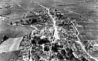 |
aerial photograph of Marshfield c. 1930, found by Mike & Chrissie Phillips |
From the evidence of Saxon charters, it seems that there was a settlement in this area from at least AD 931. Marshfield appears in the Domesday Book (AD 1086) as 'Meresfelde' -- 'that tract of open land on the boundary', the boundary in question being the one between the Saxon kingdoms of Wessex and Mercia.
The town shows clear signs of deliberate planning, probably dating back to around 1265 when the Abbot of Keynsham was granted a charter for a fair and market in Marshfield. The main elements of the town are shown clearly on the tithe map of 1841: a broad High Street with narrow burgage plots (plots rented annually to tenants) laid out along either side, running back to a pair of back lanes now called Back Lane and Weir Lane. It is likely that the High Street and the triangular area at its eastern end, near the Lord Nelson pub, may have been used as market areas.
Marshfield differs from other medieval Cotswold towns in that its economy derived from barley rather than wool. Significantly, in around 1280 the abbot was granted the taxes of bread and beer in the town, and by the 15th century, there is evidence that barley was being grown for malting. In this process, which converts the grain into fermentable material that can then be sold for brewing beer and ale, the barley is soaked, allowed to begin to germinate and then killed by heating -- all in special buildings called 'malthouses'. Marshfield at one time boasted at least 19 of these, but the last one ceased operation in the first decade of the 20th century.
Marshfield also became important in the post-medieval period as the first stage on the Bristol-London stagecoach route -- hence the large number of pubs/inns that the town once supported. The main road through Marshfield was turnpiked in the 18th century, and there were two toll houses in the town, of which only one (in the west) survives.
The malting industry prospered greatly until the second half of the 18th century, when the role of the town as a local centre declined and its economic dependence on Bath and Bristol became total. The Industrial Revolution passed Marshfield by, and as a result, it has retained much of its medieval character. The commercial life of the town in the 19th century included smithies, cooperages, timber yards and hat-making -- although, of these, virtually no trace remains today.
more Marshfield history...
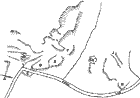 |
A plot of the earthworks of the deserted settlement at Ayford, in the south of Marshfield parish. It was mapped in 1744 (see Vince Russett's book) and was deserted in the late 18th century, at the same time as the decline in the malting industry. The letters refer to the sites of houses. |
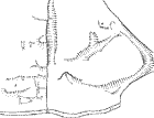 |
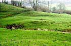
A plot of the earthworks at Brook House Green, close to West End Town and Castle Farm. At the lower right-hand side can be seen the earthworks of a building and other features by the stream, probably a mill site. On the other side of the wall, in the triangular green, can be seen hollow-ways running down to the building, and a large natural spring, emerging into what would have been the mill pond. |
 |
The earthworks of Brook House Green mill site, seen in low light from the south. Two large building platforms can be seen just above the hedge in the centre of the picture. The figures in the field are the survey team recording the earthworks. |
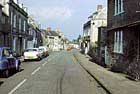 |
Marshfield High Street, looking east towards the church and market place. The clearly visible kink in the road marks a break in the building up of the town during the 13th century. The market place and Lord Nelson Inn can be seen at the far end of the street. |
 |
Looking east across the stream through the centre of the deserted settlement at Ayford. In the centre of the picture is the prominent earthwork of a large stone building still occupied in 1744, and behind it, running behind the prominent tree, the path which led to the front of the house survives as a hollow leading to the lane. |
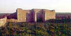 |
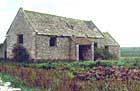
Whiteshill Barn, one of the great late 18th century barns built in Marshfield. Although this one lacks its roof, the other classic features (twin opposed porches to allow a through draft for winnowing wheat; re-used freestone quoins and window and door enclosures and slit windows) survive. |
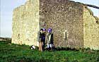 |
Whiteshill barn with survey team to scale, and showing freestone quoins and windows. |
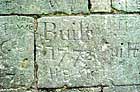 |
Datestone at Whiteshill Barn of 1772. |
 |
Cadwell Hill Barn, another late 18th century barn, in a state of disrepair in 1984, although now completely restored. |
See also Marshfield then and now
All photos on this page, except the aerial photo, are by Vince Russett.