

![]()
Spon Street
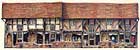 |
1 & 2 Spon Street (formerly 54-57) -- |
By the 14th century, the street pattern of Coventry had been established in a layout that would alter little over the next 600 years. One of its most striking features was the west-to-east axial road running for nearly 1.5 miles from Spon to Gosford Green. Spon End and Spon Street formed the western section of this route.
tenements and gates
The first documentary evidence of the street is from the late
12th century when it was known as 'Vicus Sponnet', 'Sponn' or
'Spanne'. At about this time, the street had 'bars' -- barriers
closing the entrance into the city, formed originally of posts,
rails and a chain -- to the west of the later Spon Gate, probably
at the end of the modern Barras Lane. Ten or more tenements (dwelling-houses)
lay between the bars and the gate site. Spon or Bablake Gate --
one of 12 on the town's defensive wall -- was built soon after
1391 with stone from Cheylesmore Park, and survived until 1771.
In 1410-11, Spon Street stretched from Smithford Bridge out as far as the old leper hospital, near the junction of the present Allesley Old Road and Hearsall Lane. By then, the portion outside the city wall was developing into the suburb of Spon, one of four or more such medieval suburbs outside the gates.
Whittawers and watchmakers
In the 12th and 13th centuries, many dyers and tanners plied their
trades in Spon Street because their noxious work required them
to be on the outskirts of the town and near a source of running
water. Deeds and other records of the time show that the street
was also occupied by combers (who combed wool), fullers (who 'fulled'
cloth - tread or beat it to cleanse or thicken it), weavers, cordwainers
(who worked in cordwain -- or cordovan -- leather, usually high-class
shoemakers), saddlers, plumbers, smiths, carpenters and carters.
There are also references to a capper, cloth dresser, woader (a
dyer using the blue dye known as woad), salter (a manufacturer
of or dealer in salt), cobbler, fletcher (a maker of or dealer
in arrows), apothecary and physician. However, in the 14th and
15th centuries, the records only make mention of dyers, tanners,
whittawers (treaters of leather) and carriers.
By the 19th century, the balance had shifted away from the cloth and leather trades to watchmaking. At the 1851 census, the Spon district was given over almost exclusively to one or other branch of the watchmaker's craft. In Spon Street alone, as many as 137 households were involved in this trade.
In 1812, Spon Street was one of six Coventry streets to be turnpiked -- that is, improved as a toll road. The construction of Lower Holyhead Road in 1827-30 relieved the street from its longstanding role as a major route into and out of the city. During that century, the open land both to the north and south of the street had been gradually built up, and by 1900, most of the houses in the street had been turned into shops, particularly towards the city centre.
bombing raids
Spon Street escaped major destruction during the bombing raids
of 1940 and 1941, but in the 1950s and 1960s, major changes took
place with the redevelopment of the Spon End district and the
construction of the inner ring road. Most of the surviving medieval
houses along the western and central sections of the street were
demolished and replaced with modern flats.
By the mid-1960s, however, there was growing concern about the disappearance of historic timber-framed houses in the city centre through wartime damage and redevelopment. It was decided to preserve the best of the remaining buildings in that part of Spon Street lying between St John's church and the ring road, and to reconstruct there timber-framed buildings that had been, or would be, dismantled from other sites.
the townscape scheme
The original scheme, launched in 1967, proposed relocating buildings
from Gosford Street, Far Gosford Street, Jordan Well and Much
Park Street, as well as from other parts of Spon Street itself
and Spon End. By 1972, however, the threat to the buildings in
Spon End and Far Gosford Street had lifted, while some other buildings
had been demolished as unsafe or were found to be incapable of
reconstruction. Eventually only properties in Much Park Street
and western/central Spon Street were allocated for re-erection
in the Spon Street Townscape Scheme.
The first building restored in the street was no. 169, in 1969-70, soon after the Spon Street Conservation Area was declared in August 1969. The first relocated building was no. 9 (formerly no. 7 Much Park Street), which was completely restored in June 1972. The scheme, when completed, contained 12 buildings restored in situ and 10 re-erected from other sites. Spon Street now has one of the most important groupings of medieval timber-framed buildings in the country.
This article was adapted from Spon Street Townscape Scheme: A guide to the history of the street and the buildings in the scheme by Mark Singlehurst and George Demidowicz of Civic Design, City Planning Services, City Development Directorate, Coventry City Council.
Back to history